Included is a set of photos concerning lipid-based formations of combined frozen CO2 and hydrocarbons in sub-zero degrees, which resemble trees, including different "species", alongside liquid lakes, with growth accorded to seasonal temperature.

* "NASA Rover Findings Point to a More Earth-like Martian Past" (2016-06-27, jpl.nasa.gov/news/news.php?feature=6544) [archive.is/tAjVf]
* "Mars is warmer than some parts of the U.S. and Canada" (2015-01-09, UPI newswire, via marsdaily.com/reports/Mars_is_warmer_than_some_parts_of_the_US_and_Canada_999.html) [archive.fo/4dsRa]
* "Similarities between aurorae on Mars and Earth; An international team of researchers has for the first time predicted the occurrence of aurorae visible to the naked eye on a planet other than Earth" (201-05-27, Aalto University, aalto.fi/en/current/news/2015-05-27/) [archive.is/SVXWD]
* "Dutch crops grown on 'Mars' soil found safe to eat" (2016-06-23, AFP newswire, via marsdaily.com/reports/Dutch_crops_grown_on_Mars_soil_found_safe_to_eat_999.html) [archive.is/oWJXc]
* "Mars has belts of glaciers consisting of frozen water" (2015-04-07, Niels Bohr Institute, University of Copenhagen, nbi.ku.dk/english/news/news15/mars-has-belts-of-glaciers-consisting-of-frozen-water/) [archive.fo/c5gx2], synopsis: Mars has distinct polar ice caps, but Mars also has belts of glaciers at its central latitudes in both the southern and northern hemispheres. A thick layer of dust covers the glaciers, so they appear as surface of the ground, but radar measurements show that underneath the dust there are glaciers composed of frozen water. New studies have now calculated the size of the glaciers and thus the amount of water in the glaciers. It is the equivalent of all of Mars being covered by more than one meter of ice. The results are published in the scientific journal, Geophysical Research Letter.
- Images showing the areas of study yielding evidence of subsurface glacial ice deposits (Credit: Mars Digital Image Model, NASA/Nanna Karlsson)


* "NASA Research Suggests Mars Once Had More Water than Earth’s Arctic Ocean" (2015-03-05, nasa.gov/press/2015/march/nasa-research-suggests-mars-once-had-more-water-than-earth-s-arctic-ocean/) [archive.fo/DDZKr]
* "Mars: The Planet that Lost an Ocean’s Worth of Water" (2015-03-05, eso.org/public/usa/news/eso1509/) [archive.fo/QCUdQ].
This artist's impression shows how Mars may have looked about four billion years ago. The young planet Mars would have had enough water to cover its entire surface in a liquid layer about 140 metres deep, but it is more likely that the liquid would have pooled to form an ocean occupying almost half of Mars's northern hemisphere, and in some regions reaching depths greater than 1.6 kilometres.


- image caption: This animation simulates a flyover of a portion of a Martian canyon detailed in a geological map produced by the U.S. Geological Survey and based on observations by the HiRISE camera on NASA's Mars Reconnaissance Orbiter. Image Credit: NASA/JPL-Caltech/Univ. of Arizona/USGS

* "POTENTIAL SIGNS OF ANCIENT LIFE IN MARS ROVER PHOTOS" (2015-01-05, astrobio.net/news-exclusive/potential-signs-ancient-life-mars-rover-photos/) [archive.fo/i5Geh]
* "AWASH IN CHEMISTRY" (2008-06-27, astrobio.net/mars/awash-in-chemistry/) [archive.fo/lAdPO] [begin excerpt]: NASA’s Phoenix Mars Lander performed its first wet chemistry experiment on martian soil, returning a wealth of data that for Phoenix scientists was like winning the lottery.
"We are awash in chemistry data," said Michael Hecht of NASA’s Jet Propulsion Laboratory, lead scientist for the Microscopy, Electrochemistry and Conductivity Analyzer, or MECA, instrument on Phoenix. "We’re trying to understand what is the chemistry of wet soil on Mars, what’s dissolved in it, how acidic or alkaline it is. With the results we received from Phoenix, we could begin to tell what aspects of the soil might support life."
"This is the first wet-chemical analysis ever done on Mars or any planet, other than Earth," Phoenix co-investigator Sam Kounaves of Tufts University, science lead for the wet chemistry laboratory investigation, said.
About 80 percent of Phoenix’s first, two-day wet chemistry experiment is now complete. Phoenix has three more wet-chemistry cells for use later in the mission.
"This soil appears to be a close analog to surface soils found in the upper dry valleys in Antarctica," Kounaves said. "The alkalinity of the soil at this location is definitely striking. At this specific location, one inch into the surface layer, the soil is very basic, with a pH of between eight and nine. We also found a variety of components of salts that we haven’t had time to analyze and identify yet, but that include magnesium, sodium, potassium and chloride."
"This is more evidence for water because salts are there. We also found a reasonable number of nutrients, or chemicals needed by life as we know it," Kounaves said. "Over time, I’ve come to the conclusion that the amazing thing about Mars is not that it’s an alien world, but that in many aspects, like mineralogy, it’s very much like Earth." [end excerpt]

===*===*===
* "Red Planet’s Mystery; While NASA plans to return astronauts to the Moon by 2020 for extended missions in search of more water, scientists say it might be a good idea to drop by to Mars as well. In 2011, the first real proof was released that there is water on the Red planet" (2014-12-04, sputniknews.com/in_depth/201412041015495388/) [archive.fo/T63OG] .
* "A Wet Red World? The Search for Water on Mars Goes On" (2011-11-04, Astrobiology Magazine, via space.com/13510-water-mars-search-life.html) [archive.fo/pSEPN]
* "The Long and Arduous Quest to Find Flowing Water on Mars May Be Over; The surface of Mars changes all the time. Is flowing water one of the causes?" (2013-05-01, scientificamerican.com/article/long-arduous-quest-find-flowing-water-on-mars-over/) [archive.fo/jztob], text (via www.nikkei-science.com/?p=37956) [archive.fo/D3KvN]
* "Curiosity Rover Makes Big Water Discovery in Mars Dirt, a 'Wow Moment' " (2013-09-26, space.com/22949-mars-water-discovery-curiosity-rover.html) [archive.fo/0LY1L]
* "Photos: The Search for Water on Mars" (2013-09-26, space.com/12542-mars-water-photos-red-planet-images.html) [begin excerpt]:
- 8 of 37: Signs of Possible Water on Mars at Newton Crater (NASA/JPL-Caltech/Univ. of Arizona)
This image combining orbital imagery with 3-D modeling shows flows that appear in spring and summer on a slope inside Mars' Newton crater.
 [...]
[...]- 10 of 37: Potential Water Ice and Salt Map of Mars (NASA/JPL-Caltech/ASU/UA/LANL/MSSS)
This map of Mars shows relative locations of three types of findings related to salt or frozen water, plus a new type of finding that may be related to both salt and water. Blue boxes are caches of water ice; white boxes are fresh craters that exposed water ice; red boxes are salt deposits that may be from salt water evaporation.
 [...]
[...]- 12 of 37: Mystery Lines on Mars Crater Might Reveal Water (Science/AAAS)
This composite image shows odd lines on slopes of Mars' Horowitz Crater, which scientists say suggest the presence of liquid salt water. These images show the central structure of Horowitz Crater, including central peaks and pits. The arrows mark locations of the odd slope features.

- 13 of 37: Recurring Slope Lines on Horowitz Crater (Science/AAAS)
These slopes carved in Horowitz crater on Mars suggest the Red Planet might current host liquid water. Colors have been strongly enhanced to show the subtle differences, including light orange streaks (black arrows) in the upper right that may mark faded lines.

- 14 of 37: Impact Crater in Mars' Newton Basin (Science/AAAS). An impact crater in Mars' Newton basin shows lines that appear to have been carved by salt water. Four side panels show these lines in the late summer on Mars (B), then faded by the next very early spring (C), then gradually darkening and reforming in the spring (D) and summer (E).

- 15 of 37: Color-Coded Clues to Composition Superimposed on Martian Seasonal-Flow Image (NASA/JPL-Caltech/UA/JHU-APL). This image combines a photograph of seasonal dark flows on a Martian slope with a grid of colors based on data collected by a mineral-mapping spectrometer observing the same area. Image released Feb. 10, 2014. Full story, "NASA Photos Show Possible Water Flows on Mars" (2014-02-10, space.com/24635-water-mars-nasa-photos-seasonal-streaks.html) [archive.is/CoAX7]

- 16 of 37: Gully Gazing: Scientists Search for Flowing Water on Mars (NASA/JPL/University of Arizona). Crater edge in Terra Sirenum has been imaged by the High Resolution Imaging Science Experiment (HiRISE) camera on NASA's Mars Reconnaissance Orbiter. Gully watching thanks to repeat sweeps over the same landscape by orbiting spacecraft could catch gullies in action, if they are active today.

- 17 of 37: Mars Once Shuffled Its Icy Poles (ESA). Pockets of water ice on the southern pole of Mars, such as these, have been stopped from their once-routine migration by a cap of dry ice, or frozen carbon dioxide. Planetary scientists think the migrations was fueled by an eccentric wobble in Mars'tilt.

- 18 of 37: Hidden Glaciers Are Common on Mars (NASA/JPL-Caltech/ASI/University of Rome/Southwest Research Institute). The Shallow Radar instrument on NASA's Mars Reconnaissance Orbiter has detected widespread deposits of glacial ice in the mid-latitudes of Mars. This map of a region known as Deuteronilus Mensae, in the northern hemisphere, shows locations of the detected ice deposits in blue.
 [...]
[...]20 of 37: NASA Gives Frozen Mars Lander Last Chance to Phone Home (NASA/JPL-Caltech/University of Arizona). Stages in the seasonal disappearance of surface ice from the ground around the Phoenix Mars Lander are visible in these images taken on Feb. 8, 2010, (left) and Feb. 25, 2010, during springtime on northern Mars, by NASA's Mars Reconnaissance Orbiter.
 [...]
[...]- 22 of 37: Giant Pool of Water Ice at Mars' South Pole (NASA/JPL/ASI/ESA/University of Rome/MOLA Science Team/USGS). This radar map shows the thickness of the south polar layered deposits of Mars (purple represents the thinnest areas and red the thickest). The dark circle is the area poleward of 87 degrees south latitude, where MARSIS can’t collect radar data.

- 23 of 37: Rivers Might Have Flowed Recently on Mars (NASA/JPL/GSFC/Malin Space Science Systems). In this perspective view looking at the inside rim of Lyot Crater on Mars, a broad lobate debris apron (left) (thought to be a debris-covered glacier) is found amongst water-carved channels. The authors argue that these ice-rich units underwent melting in the relatively high-pressure environment provided by Lyot Crater, the deepest point in the northern hemisphere of Mars.

- 24 of 37: Flashback: Water on Mars Announced 10 Years Ago (Science): The floor and banks of a Mars gully on the northwest wall of a crater in Terra Sirenium changed between December 2001 and April 2005 due to a distinct light-toned material that flowed down the slope and formed a deposit (top). The same change occurred in a crater in the Centauri Montes region (bottom).

- 25 of 37: Water Flowed on Mars More Recently Than Thought Credit: NASA/JPL/MSSS Melting glaciers spawned rivers on Mars as recently as several hundred million years ago. This image shows a river that sprang from a past glacier from an unnamed crater in Mars’ middle latitudes. Full story, "Water Flowed on Mars More Recently Than Thought" (2010-06-24, space.com/8660-water-flowed-mars-thought.html) [archive.is/HBT1A]

- 26 of 37: Young Mars Crater Contains Water Ice, Photo Shows (NASA/JPL-Caltech/University of Arizona). At the center of this view of an area of mid-latitude northern Mars, a fresh crater about 6 meters (20 feet) in diameter holds an exposure of bright material, blue in this false-color image. Full story, "Young Mars Crater Contains Water Ice, Photo Shows" (2010-10-27, space.com/9025-young-mars-crater-water-ice-photo-shows.html) [archive.is/ZDShJ]
 [...]
[...]- 29 of 37: New Evidence Suggests Icebergs in Frigid Oceans on Ancient Mars (HiRISE). Chains of crater marks on Mars such as these could have been made by icebergs rolling across ancient Martian ocean floors, researchers suggest. Full story: "New Evidence Suggests Icebergs in Frigid Oceans on Ancient Mars" (2010-10-01, space.com/9241-evidence-suggests-icebergs-frigid-oceans-ancient-mars.html) [archive.is/qjRHM]
- 30 of 37: New Map Bolsters Case for Ancient Ocean on Mars (Wei Luo, Northern Illinois University). This is a global map depicting the dissection density of valley networks on Mars, in relation to the hypothesized northern ocean. Two candidate sea levels are shown: contact 1 with mean elevation at -1,680 meters and contact 2 with mean elevation of -3,760 meters.
 [...]
[...]- 32 of 37: Study Suggests It Rained on Ancient Mars (ESA/DLR via E. Hauber). The picture shows a topographic map of a crater in the Xanthe highlands, which held a lake 3.8 to 4 billion years ago. Sediments were deposited in the lake, forming a distinctly shaped delta. The lake was fed by a river that flowed through the Nanedi valley and into the crater from the south.

- 33 of 37: Signs of Underground Plumbing Seen on Mars (NASA/JPL-Caltech/Univ. of Arizona). Dense clusters of crack-like structures called deformation bands form the linear ridges in this Mars image from the High Resolution Imaging Science Experiment (HiRISE) camera on NASA's Mars Reconnaissance Orbiter.
 [...]
[...]36 of 37: Dark Flows on Mars: NASA Images (NASA/JPL-Caltech/Univ. of Arizona). Dark, seasonal flows emanate from bedrock exposures at Palikir Crater on Mars in this image from the High Resolution Imaging Science Experiment (HiRISE) camera on NASA's Mars Reconnaissance Orbiter. Three arrows point to bright, smooth fans left behind by flows. This image was taken on June 27, 2011 and released on Feb. 10, 2014.

[end photo set]
* "NASA Orbiter Finds New Gully Channel on Mars" (2014-03-19, jpl.nasa.gov/news/news.php?release=2014-086) [archive.fo/O2eyQ] [begin excerpt]: A comparison of images taken by the High Resolution Imaging Science Experiment (HiRISE) camera on NASA's Mars Reconnaissance Orbiter in November 2010 and May 2013 reveal the formation of a new gully channel on a crater-wall slope in the southern highlands of Mars.
These before-and-after images are available online at (jpl.nasa.gov/spaceimages/details.php?id=PIA17958).
Gully or ravine landforms are common on Mars, particularly in the southern highlands. This pair of images shows that material flowing down from an alcove at the head of a gully broke out of an older route and eroded a new channel. The dates of the images are more than a full Martian year apart, so the observations did not pin down the Martian season of the activity at this site. Before-and-after HiRISE pairs of similar activity at other sites demonstrate that this type of activity generally occurs in winter, at temperatures so cold that carbon dioxide, rather than water, is likely to play the key role. [end excerpt]
- image caption: This pair of before (left) and after (right) images from the High Resolution Imaging Science Experiment (HiRISE) camera on NASA's Mars Reconnaissance Orbiter documents formation of a new channel on a Martian slope between 2010 and 2013, likely resulting from activity of carbon-dioxide frost. Image credit: NASA/JPL-Caltech/Univ. of Arizona

* "A New Gully Channel in Terra Sirenum, Mars" (2014-03-19, jpl.nasa.gov/spaceimages/details.php?id=PIA17958) [archive.is/81PnY]
* "On Mars, Liquid Water Appears at Night, Study Suggests" (2015-04-13, space.com/29072-mars-liquid-water-at-night.html) [web.archive.org] [archive.fo/g4mp3]
* "Spectral evidence for hydrated salts in recurring slope lineae on Mars" (2015-09-28, nature.com/articles/ngeo2546) [web.archive.org] [archive.fo/YEId7]
* "NASA Confirms Evidence That Liquid Water Flows on Today’s Mars" (2015-09-28, nasa.gov/press-release/nasa-confirms-evidence-that-liquid-water-flows-on-today-s-mars)
* "NASA confirms that liquid water flows on Mars; It's the first direct evidence of a long-suspected theory" (2015-09-28, theverge.com/2015/9/28/9408645/nasa-mars-water-flow-discovery-proof) [web.archive.org] [archive.fo/kMnFB] [begin excerpt]:
Liquid water exists on the surface of Mars during the planet's warmer seasons, according to new research published in Nature Geosciences (nature.com/articles/doi:10.1038/ngeo2546). This revelation comes from new spectral data gathered by NASA’s Mars Reconnaissance Orbiter (MRO), a spacecraft that studies the planet from orbit. The orbiter analyzed the chemistry of weird dark streaks that have been known to appear and disappear seasonally on the Martian surface. The analysis confirms that these streaks are formed by briny — or salty — water flowing downhill on Mars. [...]
This isn't the first study to suggest liquid water is present in some form on Mars. Scientists have theorized for years that Mars was once home to a large ocean more than 4 billion years ago. And recent findings from the Mars Curiosity rover suggest that liquid water exists just underneath the Martian surface. The discovery of water on Mars has almost become a joke among planetary scientists. Alfred McEwen, a planetary geologist at Planetary Image Research Laboratory (pirl.lpl.arizona.edu) who also worked on this research, wrote in Scientific American that the studies have become extremely commonplace: "Congratulations — you've discovered water on Mars for the 1,000th time!" he joked. [end excerpt]
- photo caption: Dark narrow streaks called recurring slope lineae emanating out of the walls of Garni crater on Mars (NASA / JPL / University of Arizona)

* "NASA confirms: Mars has liquid water" (2015-09-28, rt.com/usa/316785-nasa-water-mars-confirmed/) [archive.is/c20Mb]: For the first time, NASA has confirmed the existence of liquid water on the surface of Mars, according to new research announced Monday. The finding stems from data and analysis by NASA's Mars Reconnaissance Orbiter.
The Mars Reconnaissance Orbiter (MRO) has verified that the dark, seasonal streaks that have appeared on Mars' surface come from briny water flows.
MRO found evidence of narrow channels containing water cut into cliff walls through Mars' equatorial band, though the source and chemistry of the water is yet unknown. The streaks, or recurring slope lineae, appear during the warmer summer months on the Red Planet. They disappear when the temperature drops.
The findings advance the potentiality for life on Mars, researchers said. While it is likely that life exists in the crust of Mars, the new findings further the possibility of life closer to the surface of the planet, Alfred McEwen, a planetary scientist with Arizona State University, said during a NASA press conference.
“It took multiple spacecraft over several years to solve this mystery, and now we know there is liquid water on the surface of this cold, desert planet,” said Michael Meyer, lead scientist for NASA’s Mars Exploration Program. “It seems that the more we study Mars, the more we learn how life could be supported and where there are resources to support life in the future.”
Scientists had previously run into difficulties analyzing the streaks, which measure less than 16 feet, or 5 meters, wide. The MRO's instruments were able to process trace measurements, and scientists successfully observed the findings thanks to a computer program that can focus in on individual pixels. MRO's data was then compared with high-resolution images of the slopes. Scientists found a match between their locations and the presence of hydrated salts.
"We're not claiming that we found ... evidence of liquid water. We found hydrated salts," said Lujendra Ojha, a graduate student at Georgia Institute of Technology and lead author of the report, published in the journal Nature Geosciences.
While NASA has rushed to announce the findings, Ojha expressed reserve.
"It's a little bit over-the-top announcement by NASA," Ojha said. "There's so many mysteries to be solved about RSL (recurring slope line)."
The presence of water on Mars in the form of ice caps has been known for years. However, proof of liquid water on the Red Planet will have major ramifications for the study of Mars. It may mean that microbial life may still survive under the Martian surface, if there ever was any in the first place.
The discovery "confirms that water is playing a role in these features," according to McEwen. "We don't know that it's coming from the subsurface. It could come from the atmosphere."
NASA's Mars rover Curiosity previously found evidence that Mars had suitable conditions for microbial life that existed at some point in the past.
During the summer, Mars can reach up to 70 degrees Fahrenheit along its equator. Ojha and his research team found that this high temperature -- far from the planet's average of -80 degrees Fahrenheit -- allowed salty water to flow down the planet's slopes. The water combines with perchlorates to form a brine solution that helps the water to remain a liquid as temperatures drop.
"We found the hydrated salts only when the seasonal features were widest, which suggests that either the dark streaks themselves or a process that forms them is the source of the hydration. In either case, the detection of hydrated salts on these slopes means that water plays a vital role in the formation of these streaks," Ojha said.
* "All of the places scientists have found water flowing on Mars" (2015-10-06, businessinsider.com/where-is-the-water-on-mars-2015-10) [archive.fo/H26Tz] [begin excerpt]:
Here, in Coprates Chasma, you can clearly make out recurring slope linae (RSL) against the bedrock. HiRISE images like this one often have false colors that highlight distinct features like sand dunes and these linae flows. (NASA/JPL/University of Arizona)

One of the most active places on Mars is the mountainous bedrock in Hale Crater. Here, you can see RSL sliding down the bedrock's steep slopes. (ASA/JPL/University of Arizona)

Juventae Chasma is an enormous canyon on Mars that scientists suspect could have formed from powerful flowing rivers billions of years ago. Shown below is a region of the canyon with evidence of much smaller water flows today. (NASA/JPL/University of Arizona)

One of the largest geographical changes on Mars ever observed is located in a crater on the floor of Melas Chasma. The giant dark streak is 59 feet wide — almost 4x larger than the average RSL. Scientists aren't sure what this feature is, but they're monitoring it closely to see if it behaves similarly to an RSL. (NASA/JPL/University of Arizona)

The HiRISE camera has taken multiple photos of this spot in Palikir Crater during different seasons. From the photos, scientists learned that RSL change over time, growing larger in later spring and early summer, and disappearing entirely throughout winter. (NASA/JPL/University of Arizona)

The RSL in this photo are almost invisible, suggesting that this region of Mars, in Raga Crater, is either entering or in the midst of winter. The linae will reappear the following spring and summer. (NASA/JPL/University of Arizona)

RSL flow down Newton Crater in this shot. Since its arrival to Mars in 2006, the HiRISE camera has recorded how these RSL change each time the reappear. Interestingly, they take on the same shape as the year before. Why that happens remains a mystery. (NASA/JPL/University of Arizona)

During the Martian winter, carbon dioxide ice carves ravines, shown below, into the Martian surface. Then, when temperatures warm up, RSL has been seen flowing out of some of these ravines. (NASA/JPL/University of Arizona)

At the center of the 65-mile-wide Porter Crater is a peak with shallow gullies and possibly RSL. Scientists only have this one photo of the crater, so they will need more to determine whether what they're seeing is actually RSL or something different. (NASA/JPL/University of Arizona)

Asimov crater — named for American biochemist and author Isaac Asimov — is a mysterious spot. Certain regions of the crater are rich with RSL while other similar locations are devoid of any. (NASA/JPL/University of Arizona)

Here's another shot of Asimov Crater and its mysterious deep troughs. Scientists don't know how these troughs formed, but they're typically a great spot to see RSL. There are no RSL in this photo because it was taken during winter. (NASA/JPL/University of Arizona)

Though RSL are linked to flowing water on Mars, scientists aren't sure where this water is coming from or how much of it exists. To better understand this, they're seeking out more locations on Mars where RLS appear, like in gullies shown in bright blue below. (NASA/JPL/University of Arizona)

[end excerpt]
From [marsanomalyresearch.com]: Mars Surface Water in a liquid state [archive.is/wr8sP]
===*===*===
* "Methane debate splits Mars community" (2011-09-12, astrobio.net/news-exclusive/methane-debate-splits-mars-community/) [archive.fo/sCB8W]
- image caption: This image shows concentrations of methane discovered on Mars.

* "Spike seen in methane on Mars, but source unknown" (2014-12-16, AFP newswire, via marsdaily.com/reports/Spike_seen_in_methane_on_Mars_but_source_unknown_999.html) [archive.today/v8fh6] [begin excerpt]: Methane, a gas that on Earth comes mainly from living organisms, has been measured for the first time making a sudden spike on Mars, leaving scientists puzzled about its origin.The latest findings from NASA's Curiosity rover, which has been exploring the Red Planet since it landed in 2012, were published in the US journal Science on Tuesday and raise the question, could microbes be the source of the methane? And what caused the levels to soar and dissipate again in a matter of weeks? [end excerpt]
* "Mystery methane on mars: the saga continues; A scientist has raised questions about the latest detection of methane on Mars, suggesting that NASA’s rover could be responsible for the mysterious burp. Highly unlikely, but not impossible, says the Curiosity team" (2015-05-14, astrobio.net/news-exclusive/mystery-methane-on-mars-the-saga-continues/) [archive.is/c1Tdg]
===*===*===
* "How NASA Curiosity Instrument Made First Detection of Organic Matter on Mars" (2014-12-16, jpl.nasa.gov/news/news.php?feature=4414) [archive.fo/SZu74]
* "NASA Rover Finds Active and Ancient Organic Chemistry on Mars" (2014-12-17, JPL, via marsdaily.com/reports/NASA_Rover_Finds_Active_and_Ancient_Organic_Chemistry_on_Mars_999.html) [archive.fo/QygDZ]
===*===*===
"Meteorite From Mars Contains Alien Biomass" (2014-12-04, marsdaily.com/reports/Meteorite_From_Mars_Contains_Alien_Biomass_999.html) [archive.fo/E7hQD]
* "Traces of possible Martian biological activity inside a meteorite" (2014-12-03, via SPX newswire, marsdaily.com/reports/Traces_of_possible_Martian_biological_activity_inside_a_meteorite_999.html) [archive.is/4fJcu]
* "Martian meteorite yields more evidence of the possibility of life on Mars" (2014-09-16, via SPX newswire, marsdaily.com/reports/Martian_meteorite_yields_more_evidence_of_the_possibility_of_life_on_Mars_999.html) [archive.is/9s2fX]
- File image: Martian meteorite Nakhla.

* "A Salty, Martian Meteorite Offers Clues to Habitability" (2014-08-29, NASA, via marsdaily.com/reports/A_Salty_Martian_Meteorite_Offers_Clues_to_Habitability_999.html) [archive.fo/aUMSo]
- image caption: This meteorite, EETA79001, a basalt lava rock nearly indistinguishable from many Earth rocks, provided the first strong proof that meteorites could come from Mars. Originally weighing nearly 8 kilograms (17.6 pounds), it was collected in 1979 in the Elephant Moraine area of Antarctica. Image courtesy NASA/JSC/JPL/Lunar Planetary Institute.

===*===*===
* "Traces of possible Martian biological activity inside a meteorite" (2014-12-03, via SPX newswire, marsdaily.com/reports/Traces_of_possible_Martian_biological_activity_inside_a_meteorite_999.html) [archive.is/4fJcu]
* "Martian meteorite yields more evidence of the possibility of life on Mars" (2014-09-16, via SPX newswire, marsdaily.com/reports/Martian_meteorite_yields_more_evidence_of_the_possibility_of_life_on_Mars_999.html) [archive.is/9s2fX]
- File image: Martian meteorite Nakhla.
* "A Salty, Martian Meteorite Offers Clues to Habitability" (2014-08-29, NASA, via marsdaily.com/reports/A_Salty_Martian_Meteorite_Offers_Clues_to_Habitability_999.html) [archive.fo/aUMSo]
- image caption: This meteorite, EETA79001, a basalt lava rock nearly indistinguishable from many Earth rocks, provided the first strong proof that meteorites could come from Mars. Originally weighing nearly 8 kilograms (17.6 pounds), it was collected in 1979 in the Elephant Moraine area of Antarctica. Image courtesy NASA/JSC/JPL/Lunar Planetary Institute.
===*===*===
* "The Banyan trees of Mars: Sir Arthur C. Clarke's minority view" (2001-12, by Nicole Foulke, Popular Science magazine, popsci.com/popsci/aviation/article/0,12543,188720,00.html) [archive.is/Sd2LU], also archived at [archive.is/TikyA]:
"I'm now convinced that Mars is inhabited by a race of demented landscape gardeners," Sir Arthur C. Clarke announced recently.
The author of 2001: A Space Odyssey was only half-joking. He claims that an image produced by the Mars Global Surveyor satellite shows "large areas of vegetation . . . like banyan trees." Most experts dismiss the idea. But Popular Science loves a free thinker, especially one as talented and charming as Sir Arthur. We questioned him in Sri Lanka via e-mail.
- [Popular Science]: What makes you so confident there is life on Mars?
- [Arthur C. Clarke]: The image is so striking that there is no need to say anything about it -- it's obviously vegetation to any unbiased eye.
- [PS]: What about animal life?
- [AC]: If there is vegetation, it seems probable there are other life-forms as well.
- [PS]: Few experts agree with you.
- [AC]: Remember how a certain Astronomer Royal said that space flight was 'utter bilge'? [Indeed, Richard van der Reit Wooley said so in 1956 -- Ed.] But they are right to be cautious -- we still don't have 100 percent proof. I think it's in the high nineties!
- [PS]: Why are you so passionate about this?
- [AC]: Because nothing could be more important than the discovery of other life-forms. It's getting lonely down here.
Photo caption: Clarke believes plants row in the Red Planet's southern hemisphere

* "Interview with: Arthur C. Clarke" (2004-02-18, theonionavclub.com; via martianspiders.com) [https://web.archive.org/web/20060824211152/http://www.martianspiders.com/onion.htm] [https://archive.is/K2jgm] [begin excerpt]:
O: Are you ever disappointed that we haven't come any closer to the technology of 2001 than we have?
* "A.C. Clarke's Trees"
(2001, marsunearthed.com/SelectedImages/ACClarkeTrees/ACClarkeTrees.htm)
[web.archive.org] [archive.is/r4c5h]:
Click on any of the images below to view the original and ancillary data at Malin Space Science Systems. From: M0804688 [archive.fo/Zfu0W] [archive.fo/z3ntz]


* MOC narrow-angle image M08-04688 (released 2000-10-16, Malin Space Science Systems, barsoom.msss.com/moc_gallery/m07_m12/images/M08/M0804688.html) [web.archive.org] [archive.fo/FzpBo]:
- View full-size image, processed, in sinusoidal projection using 284.38°W as prime meridian
(lossy JPEG, medium quality, rapid download) (barsoom.msss.com:80/moc_gallery/m07_m12/jpegmaps/M08/M0804688.jpg) [web.archive.org] [archive.fo/RMCFm]
- View full-size image, processed, in sinusoidal projection using 284.38°W as prime meridian (lossless GIF, best quality, slow download) (barsoom.msss.com:80/moc_gallery/m07_m12/maps/M08/M0804688.gif) [web.archive.org] [peeep.us/066b90bb]
- View full-size image, processed but NOT map-projected (barsoom.msss.com:80/moc_gallery/m07_m12/nonmaps/M08/M0804688.gif) [web.archive.org] [archive.fo/RU6sZ]

* Note: Consisting of the hydrocarbon elements that exist under the surface, these colonies of lipid-based life erupt like a fungus from the soil in the form of "trees"... theoretically not "alive" in the Earthly sense, these colonies exist despite the rapid change in temperature day by day until they succumb to the seasons. Their ionic field ("life force") holds their elements together despite winds and weight...
* "Spider-Ravine Models and Plant-like Featureson Mars - Possible Geophysical and Biogeophysical Modes of Origin" (2001, http://www.martianspiders.com/martianspiders.pdf) [https://web.archive.org/web/20180823005647/http://www.martianspiders.com/martianspiders.pdf], synopsis:
 [...]
[...]
* "Defrosting Polar Dunes - 'They Look Like Bushes!' " (1999-08-10, mars.jpl.nasa.gov/mgs/msss/camera/images/8_10_99_releases/moc2_166/) [archive.is/FNv0a]
 "They look like bushes!" That's what almost everyone says when they see the dark features found in pictures taken of sand dunes in the polar regions as they are beginning to defrost after a long, cold winter. It is hard to escape the fact that, at first glance, these images acquired by the Mars Global Surveyor (MGS) Mars Orbiter Camera (MOC) over both polar regions during the spring and summer seasons, do indeed resemble aerial photographs of sand dune fields on Earth--complete with vegetation growing on and around them! Of course, this is not what the features are, as we describe below and in related picture captions. Still, don't they look like vegetation to you? Shown here are two views of the same MGS MOC image. On the left is the full scene, on the right is an expanded view of a portion of the scene on the left. The bright, smooth surfaces that are dotted with occasional, nearly triangular dark spots are sand dunes covered by winter frost.
The MGS MOC has been used over the past several months (April-August 1999) to monitor dark spots as they form and evolve on polar dune surfaces. The dark spots typically appear first along the lower margins of a dune--similar to the position of bushes and tufts of grass that occur in and among some sand dunes on Earth.
Because the martian air pressure is very low--100 times lower than at Sea Level on Earth--ice on Mars does not melt and become liquid when it warms up. Instead, ice sublimes--that is, it changes directly from solid to gas, just as "dry ice" does on Earth. As polar dunes emerge from the months-long winter night, and first become exposed to sunlight, the bright winter frost and snow begins to sublime. This process is not uniform everywhere on a dune, but begins in small spots and then over several months it spreads until the entire dune is spotted like a leopard.
The early stages of the defrosting process--as in the picture shown here--give the impression that something is "growing" on the dunes. The sand underneath the frost is dark, just like basalt beach sand in Hawaii. Once it is exposed to sunlight, the dark sand probably absorbs sunlight and helps speed the defrosting of each sand dune.
This picture was taken by MGS MOC on July 21, 1999 [archive.is/yb9QX] [archive.is/NHBdJ]. The dunes are located in the south polar region and are expected to be completely defrosted by November or December 1999. North is approximately up, and sunlight illuminates the scene from the upper left. The 500 meter scale bar equals 547 yards; the 300 meter scale is also 328 yards.

Additional pictures and discussion of defrosting polar dunes are shown in:
MOC2-167, Defrosting Polar Dunes--"The Snow Leopard", 10 August 1999 (https://mars.jpl.nasa.gov/mgs/msss/camera/images/8_10_99_releases/moc2_167/index.html)
MOC2-168, Defrosting Polar Dunes--Changes Over a 26-Day Period, 10 August 1999 (https://mars.jpl.nasa.gov/mgs/msss/camera/images/8_10_99_releases/moc2_168/index.html)
MOC2-169, Defrosting Polar Dunes--Dark Spots and Wind Streaks, 10 August 1999 (https://archive.is/o/FNv0a/https://mars.jpl.nasa.gov/mgs/msss/camera/images/8_10_99_releases/moc2_169/index.html)
MOC2-170, Dune Activity in Proctor Crater, 10 August 1999 (https://mars.jpl.nasa.gov/mgs/msss/camera/images/8_10_99_releases/moc2_170/index.html)
Also, from 1998, see:
MOC2-61, Spring Time View of North Polar Sand Dunes, 7 August 1998 (https://mars.jpl.nasa.gov/mgs/msss/camera/images/8_7_98_n_erg_rel/index.html ).
MOC2-72, Evidence for Recent Wind Action on Martian Sand Dunes, 29 October 1998 (https://mars.jpl.nasa.gov/mgs/msss/camera/images/10_29_98_gsa_release/10_29_98_dunes_rel/index.html)
Malin Space Science Systems and the California Institute of Technology built the MOC using spare hardware from the Mars Observer mission. MSSS operates the camera from its facilities in San Diego, CA. The Jet Propulsion Laboratory's Mars Surveyor Operations Project operates the Mars Global Surveyor spacecraft with its industrial partner, Lockheed Martin Astronautics, from facilities in Pasadena, CA and Denver, CO.
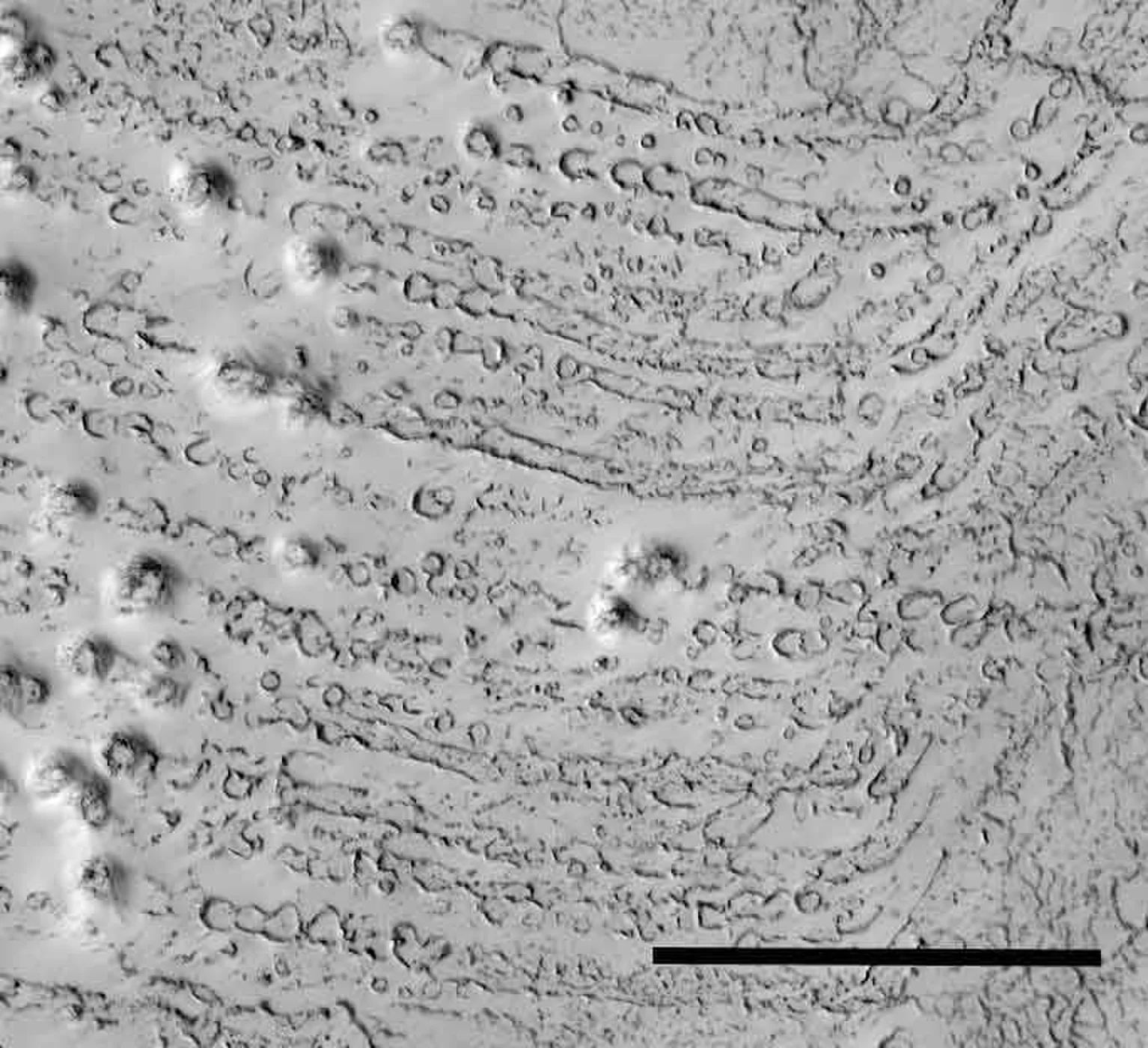
* "A forest on Mars" (2005, by Mirko Elviro, mmmgroup2.altervista.org/e-trees.html) [archive.is/Bw9sL] [begin excerpt]:
The possibility of existence of life forms on other planets has always charmed men. But only in fairly recent times the means with which we can explore celestial bodies in a scientific manner have become available. Countless probes have been launched toward planets belonging to our solar system, to study their characteristics and to understand if any form of life may have developed on them. Among planets, Mars is still the more studied planet, both for the proximity to the Earth and mainly because it is the most Earth-similar celestial body and maybe it's able to receive any type of living organism.
There's an opinion shared among scientists by now that says that if we'll find life on Mars, it surely won't have an evolutionary stage higher than the one of a bacterium. It's an opinion that has become a dogma with the passing of time, supported even in the presence of photographic documents, still without explanation, that could invalidate it.
It's the case of a photo taken by MOC (Mars Orbiter Camera), a satellite for photographical mapping of Mars that, at latitude -82.02°, longitude 284.38° (near to the Martian south pole) has filmed something totally incredible, but still neglected: it's some form of vegetation on Mars.
The photo number is M0804688 [archive.is/fGk3Z] (via msss.com), full size image [archive.is/qeN9d].
Detail of photo M0804688 taken by MOC satellite that depicts the Mars surface (6.79 m/pixel)

As one can see in the image, shapes very similar to big trees (with branches) seen by above are visible.
For example, let's compare the MOC shot (negative inversion) [archive.is/zL9xV], with this other photo [archive.is/MAOKB], that portrays a terrestrial tree [archive.is/MAOKB]: there are really many similarities.

Here's the complete "strip" taken by MOC, that shows plants becoming more and more thick, actually creating a forest. A geological phenomenon vaguely similar to this doesn't quite exists. The high resolution photo is visible by clicking here (259Kb) [archive.is/brtEp].
But then, what is the explanation? The simplest explanation is that some vegetable life forms (perhaps dating back to times when water was abundant on Mars) continue to grow on the planet, probably sinking their roots in a partially frozen water layer and able to bear strong changes in temperature.
In regard to their size, the biggest trees visible in the image have a diameter of about 1 kilometer. It obviously may seem too much, if it's compared with a terrestrial tree. But if we consider that:
1. atmosphere is more rarefied than the terrestrial one
2. gravity is only a third of the one of our planet
3. probably there are no parasites that can attack them
4. it's an alien species, surely unknown to us, with a different metabolism,
then their huge dimensions become more acceptable. Anyway in the photo we can see also more "normal-sized" trees.
Unfortunately no scientist accurately studied this document, because the "official science" says we cannot find trees there. Stop. But the "Martian forest" continue to grow regardless.
Link to the MOC official photo M0804688 (via ida.wr.usgs.gov) [archive.is/ZDXBG] [archive.is/BfL91].
This isn't the only evidence of vegetable life on the red planet, other images taken by MOC exist which show what could be brushes grown among dunes (E05-760, 2001-06-08).

Let's compare it with this satellite photo showing a desertic area of Australia:

In this image of the martian surface we can observe what is resembling a wood seen from above (MOC2-166) [archive.is/FNv0a]:

Here we see what really seems to be a lake (photo MOC m0901354, 2.75m/pixel) [archive.is/pWQcz]:

Here too (MOC m0902042) [archive.is/2IbO2]:

And in these photos too (click to view): e0801033 [archive.is/EUXy5], e0900020 [archive.is/bQU3i], e0900304 [archive.is/HKdwO] (this one at a 3.5 m/pixel resolution).
The following picture was acquired by the Opportunity probe on December, 19 2004 and it needs no comments (to the right there is a zoom of the yellow box). The original photo is visible by clicking HERE [archive.is/saD1A].

Here we have two other meaningful images which show the growth of vegetation on the red planet (MOC m1001442):


Click here for another photo showing vegetation on Mars (646 Kb) [archive.is/B3V8g].
It must be noted that unfortunately the Mars Global Surveyor has a camera (MOC) that shows only the red and the blue color, but not the green. It's probably the only camera ever constructed that has this feature, and I leave to your imagination what may be the reason for this technological choice....
Final note: probably not all people know that a certain amount of methane has been found in the Martian atmosphere (it was detected by Mars Express, by NASA's Infrared Telescope Facility in Hawaii, by International Gemini South observatory in Chile, by Mars Express Planetary Fourier Spectrometer (PFS) etc...).
Methane is not a stable molecule in the atmosphere, it vanishes after a few hundred years. Then if it's still present, it must be regenerated in some way. Two are the possibilities: either volcanic activity or bacterial production.
It exists a third hypotesis too: methane may be generated by the impact of a comet on Mars, but nobody found any recent sign of collision on the surface, and anyway it couldn't have produced long-lasting effects.
It's difficult to support the first hypothesis, because the TES on Mars Global Surveyor and the Themis on Mars Odyssey (thermical sensors with a resolution of 100 meters) never detected any volcanic activity on Mars.
Then the second hyphotesis is the most likely, there seems to be some sort of biologic activity on Mars.
UPDATE October, 6th 2006: currently there is the actual possibility to observe forests and lakes in color and with great detail, the proof is the photo taken from orbit by Mars Reconnaissance Orbiter that shows perfectly the Opportunity probe on the red planet surface [archive.is/DQw5i], and even the tracks that its wheels left on the sand. At this point one question arises: what is NASA waiting for before taking pictures of the most interesting zones and finally solving some mysteries?

* " 'Trees' on Mars?" (by S. Holland) [archive.is/LyBy2]
* Mars Global Surveyor pictures:
- M0804688 [archive.is/ZDXBG], photo [archive.is/BfL91]

- M0804874 [archive.is/Fw8xk], photo [archive.is/NsZdZ], closeup A [archive.is/dSoks], B [archive.is/DvIJO]
- M0401220 [archive.is/pMSj4], photo [archive.is/EGRx8], closeup A [archive.is/SfsG9], B [archive.is/IyMwy]
- E0500762 [archive.is/rvy3e], photo [archive.is/utiOA], closeup C [archive.is/ZbPLs], D [archive.is/oPaaO]
- M0801095 [archive.is/bPSpJ], photo [archive.is/Qnb29], closeup A [archive.is/eThR3], B [archive.is/EwChp]
- M0804580 [archive.is/dCtmL], photo [archive.is/hM7px], closeup [archive.is/oheYi]
- M0902042 [archive.is/PUdH4], photo [archive.is/2IbO2], closeup A [archive.is/iTGD6], B [archive.is/jWlEN]
- M053408 [archive.is/QgQ0i], photo [archive.is/FxvO0], closeup A [archive.is/5aQem], B [archive.is/j4Psq]
- M008405 [archive.is/cELdv], photo [archive.is/Ch5CR], closeup A [archive.is/xkHw5], B [archive.is/ynmxM], C [archive.is/MeGK9]
- M0307336 [archive.is/vwk6X], photo [archive.is/LsZlI], closeup A [archive.is/BaQ2p], B [archive.is/uUSYf], C [archive.is/2K1Fw]
- M0701643 [archive.is/e6Iw7], photo [archive.is/vuzDR], closeup A [archive.is/0WFfo], B [archive.is/rCEFr], C [archive.is/sFjF8]
- M09-01354 [archive.is/LgYBT], photo [archive.is/L0Uye]
- M0305635 [archive.is/svLu7], photo [archive.is/jUAbH]
- M0402115 [archive.is/yLJzh], photo [archive.is/NvtwC]
- M1000205 [archive.is/NFINl], photo [archive.is/z5mbe]
- M1001442 (via ida.wr.usgs.gov) [archive.is/n2onZ], photo [archive.is/YYKEf]; (via msss.com) [archive.is/7uggH], photo [archive.is/7ELRO]:

* More photos:
- E05760 (2001-06-08)
- MOC2-166 [archive.is/FNv0a]
- M0902963 (1999-11-12) / M0307643 (1999-08-09)
- M0306104 (1999-08-01)
- M0401220 (1999-08-16)
- M0705692 (1999-09-29)
- MOC2-207 [archive.is/oOcKI]
MOC narrow-angle image S06-00607 (msss.com) [archive.is/I0NPo], photo [archive.is/pDruc], closeup:

* Comparison chart showing growth within 9 months during the transition form winter to summer on Mars:

* comment (2004-11-10): Martianspiders.com has lots of images, mainly (as the name suggests) of features with a "spidery" appearance, but also a lot which I would classify as "tree-like", as well as "dalmatian dunes".
There are some interesting things in there, for instance (martianspiders.com/old/wepe6F.jpg) [archive.is/qjnBl] [peeep.us/f185a328], if you didn't know better you might swear that this was a tree-lined highway and railway line running along the side of a lake studded with small islands.

And (martianspiders.com/old/wpe84.jpg) [archive.is/duIoF] [peeep.us/11145727], don't those look like piers sticking out into a harbour?

But I don't think anybody is saying that there are actual Banyan trees on Mars, similar, if not identical to, the Banyans of Earth. I think practically everybody realises that Mars is too cold for that. The claim is that tree-like appearance is evidence of tree-like growth, which suggests (but does not prove conclusively) that the phenomenon is biological in nature.
And before anyone starts accusing, no I'm not saying that there are actual highways or railway lines or docks on Mars. Only that there are a lot of very strange phenomena, and we have only just begun to scratch the surface. There was once a site (I think it was www.marsanomalies.com) which did claim that the things which look like lakes in the middle of forests really are lakes in the middle of forests, and that furthermore the lakes are connected together by building-lined channels. The site seems to have gone now, which is unfortunate because it had a lot of the best "forest-like" images all together in one place, as well as lots of other interesting anomalies.
[end comment]
Don't humans naturally see what we are accustomed to recognizing?
* "Life-on-Mars, the smoking gun: Herd life forms", posted at (2015-10-16, warosu.org/sci/image/EElXrl5Nl0XmnF1Zs9W2mA) [archive.is/UTaqc], photo montage (i.warosu.org/data/sci/img/0075/93/1445018188032.jpg) [archive.is/cbcJ0], showing geological formations in patterns resembling the herding activity of animals from Earth, posted as part of a trolling effort to help researchers recognize their own bias when seeing the "Forests of Mars".

Aren't the "lakes" really elevated plateaus called mesas?
* "Happy Valentine's Day From Mars!" (2000-02-11, Mars Global Surveyor, Malin Space Science Systems, msss.com/mars_images/moc/2_11_00_valentines/) [archive.is/oOcKI]:
Happy St. Valentine's Day from the Red Planet! The Mars Global Surveyor (MGS) Mars Orbiter Camera (MOC) captured this unique view of a bright, heart-shaped mesa in the south polar region on November 26, 1999. This feature is located in the Promethei Rupes region near 79.6°S, 298.3°W. Sunlight illuminates the scene from the lower left. The heart is about 255 meters (279 yards) across. The presence of this mesa indicates that the darker, rough terrain that surrounds it was once covered by a layer of the bright material.

Earlier in 1999, MGS MOC saw another valentine heart, but instead of a mesa, the feature was expressed as a pit. You can view that image by CLICKING HERE ("From Mars, With Love", 1999-06-17, msss.com/mars_images/moc/6_17_99_heart/index.html) [archive.is/NFGFH] , image (msss.com/mars_images/moc/6_17_99_heart/moc2_135a_msss.gif) [archive.is/g7o7h].

If the heart looks to you like it is a pit (negative relief) rather than a mesa (positive relief), that is because there are two effects that make this a challenging object to see. Sunlight illuminates the heart from the lower left, thus the lower left wall of the heart looks bright because it is reflecting this sunlight. The problem here is frost. Some very small amounts of residual frost are seen on the slopes facing away from the sunlight (toward the lower right and toward the top). MOC images in the martian polar regions can sometimes fool the eye because a frosted slope might at first glance seem to be a sunlit slope. This picture was taken in late southern spring in a region that spends each winter and most of each spring completely buried in bright frost.
[end article]
* " 'Happy Face' Crater Greets MGS at the Start of the Mapping Mission" (1999-03-11, Mars Global Surveyor, Malin Space Science Systems, msss.com/mars_images/moc/3_11_99_happy/index.html) [archive.is/nFcHa]

===*===*===
* "CURIOSITY MAHLI Anomalies-2" (marsanomalyresearch.com) [archive.is/TyR1C]: This report zeros in on only a small bit of discarded substance that is out of place in this Mars crater floor environment and as such requires a little elaboration. It is photographed by the MSL Curiosity rover MAHLI (Mars Hand Lens Imager) camera on the Sol 065 page and exists in all but three images on that Sol 065 page. I picked the 2nd horizontal row of images and the 3rd from the left image to work with but any of several other images there would do just as well although I suspect would not be better than the one I've used. Now here's the evidence. [...]

===*===*===
* "Huge Nozzle shooting liquid spray" (marsanomalyresearch.com) [archive.is/RofAW]

- Note: This could be a hollow stalactite whose brackish water accumulates minerals around the "nozzle"...
(MOC m0902042) [archive.is/2IbO2]

===*===*===
* "Eerie image of Martian ‘dust devil’ captured by NASA’s Opportunity rover" (2016-04-05, rt.com) [is.gd/tE6h5x]:
An impressive, albeit somewhat eerie, picture of a dust devil whirling through a valley on the surface of Mars has been captured by a NASA rover from its perch high on a ridge.
The photo shows the six-wheeled robot’s tracks in the foreground, leading up the north-facing slope of "Knudsen Ridge", which forms part of the southern edge of "Marathon Valley".
Meanwhile, the dust devil can be seen twisting in the background. While dust devils are common on Mars and have been caught on camera by NASA’s other rover, Spirit, the Opportunity (MER-B) rover had not been so lucky in spotting the red planet’s twisters.
This sighting was recorded on March 31 during the 4,332nd day of the rover’s mission on Mars.
During the uphill drive to reach the top of Knudsen Ridge, Opportunity's tilt reached 32 degrees, the steepest ever for any rover on Mars.
Opportunity landed in Meridiani Planum, located 2 degrees south of Mars' equator in 2004, three weeks after its twin Spirit (MER-A) touched down on the other side of the planet. Spirit ceased communications in 2010.
Dust devils are also common on Earth and are formed when a rising, rotating column of hot air whirls at speed, picking up tiny grains of dust from the ground in the process, making the vortex visible.
On Mars, however, stronger updrafts are needed to create the dust devils, which tend to grow bigger than their counterparts on Earth.
* "NASA's Mars Reconnaissance Orbiter catches whirling Martian Dust Devil" [youtu.be/WnfaY-DCTYI]

===*===*===
* "Eaten away by ‘vog’: Acid fog eroding rocks on Mars" (2015-11-08, rt.com) [archive.is/Hy5wY]
* "Signs of acid fog found on Mars" (2015-11-02, The Geological Society of America) [archive.is/Vztix]

===*===*===
* "What Color is the Red Planet, Really?" (2013-03-20, blogs.discovermagazine.com) [archive.is/hi0HT] [begin excerpt]: Sounds like a trick question, doesn’t it? Sort of like “Who is buried in Grant’s Tomb?” And yet the answer keeps confounding a lot of smart people. (DISCOVER even published a whole feature on the question.) Now the issue keeps coming up again in the latest images from the Curiosity rover. Blue skies on Mars? Can that be right? Which of these images shows what Mars really looks like?
The very first Viking images from the surface of Mars in July, 1976 showed blue skies, largely because that’s what people were expecting and so that is how the imaging experts initially set the color balance. They quickly realized their error and reissued the image with tangerine skies.
The Martian atmosphere is fully of orange tinted dust that dominates the color of the sky, it turns out. Changing the color balance to reflect that unexpected reality was a fairly straightforward adjustment, and yet even today images of the same scene on Mars often seem to take on different tones. Sometimes the landscape looks ruddy and rusty, sometimes tangerine, sometimes butterscotch, sometimes a drab brownish yellow.
Different magazines and web sites make their own color adjustments, of course, and there are plenty of amateurs out there doing their own corrections and distortions. But NASA itself still seems confused at times about what Mars really looks like. Consider three images of Mars from space. The first two are from the Hubble Space Telescope. The third is from the Mars Global Surveyor. You’ll notice that they don’t match up very well, even though Mars is very much the same planet and two of the images even come from the exact same telescope.
The short explanation is that color balance is a highly subjective thing. No two spacecraft use the exact same filters; even two instruments on the same telescope can use different filters and channels. Once the data come in from the digital detectors, then the imaging specialists process the data to make the most meaningful kind of picture. Sometimes they highlight what seems most scientifically significant. Sometimes they try to simulate what the human eye would see–what most people mean when they ask, “What does it really look like?” But even then, the color receptors of the human eye do not match up exactly with any of our instruments, so creating a color balance that resembles human vision is itself something of a subjective art.
The confusions and the lies are as old as photography itself, and digital imaging only makes the manipulations easier and the subjectivity more evident.
At least there is a solid scientific motivation for NASA’s latest color manipulations. The white-balanced color adjustment that turns the sky blue in the latest Curiosity panoramas from Mars’s Gale Crater are designed to make the surface rocks look the way they would under normal terrestrial illumination. That makes life easier for planetary geologists who are used to looking at rock formation on Earth, and so simplifies the process of understanding the exotic setting where Curiosity is exploring. [end excerpt]
Is this the real Mars? A mosaic from NASA’s Curiosity rover shows Mount Sharp in raw color. NASA describes raw color as the way the scene would look “in a typical smart-phone camera photo.” (Credit: NASA/JPL-Caltech/MSSS)

Or is this the real Mars? The scene has been given a white-balanced color adjustment that turns the sky blue. That change simulates Earth-like lighting, making it easier to interpret the geology. (Credit: NASA/JPL-Caltech/MSSS)

Mars as seen by the Hubble Space Telescope in July, 2001. (Credit: Credit: NASA and The Hubble Heritage Team)

Mars as seen by the Hubble Space Telescope in March, 1997. (Credit: David Crisp; the WFPC2 Science Team; NASA)

Mars as seen by the Mars Global Surveyor in February, 2006. Say, that planet doesn’t look red at all. (Credit: NASA/JPL/Malin Space Science Systems)

This 1894 map of Mars was prepared by Eugene Antoniadi and redrawn by Lowell Hess.

===*===*===
* "Stonehenge on Mars? UFO hunter spots strange rock formation on red planet" (2015-09-25, rt.com) [archive.is/VEe30]

===*===*===
What would it be like to be on Mars? Listen...
"Descender" [youtube.com/watch?v=jSdsHJL9W5w], by Verbrilli Sound, sampling from "Adventures in Sound and Space" (1958, RCA Victor Bluebird LBY-1013) with voices from Col. Frank Erhardt & Cast (discogs.com/Col-Frank-Erhardt-Cast-Adventures-In-Sound-And-Space/release/2952025)

===*===*===
Mars Unearthed website

* Welcome (retrieved 2001-06-20, marsunearthed.com:80/index.html) [web.archive.org] [archive.fo/25Ewg]
* MISSION STATEMENT (retrieved 2001-08-13, geocities.com:80/marsunearthed/) [web.archive.org] [archive.fo/1rxmR]:
"Mars UnEarthed" is intended to be a forum to present and analyze, where possible, anomalous imagery of Mars from the Mars Global Surveyor satellite made public by NASA/JPL through the release of 27,500+ images on approx. June 2, 2000 and any noteworthy imagery released subsequent to this initial release. This web site will also present any issues which we believe to be related to this information. All imagery presented herein will have links to the original imagery, where relevant, published by "Malin Space Science Systems" (msss.com), contractor to NASA/JPL for the imaging and processing of Mars Orbital Camera (MOC) imagery.
Be forewarned: the imagery presented herein, along with the interpretations, is nothing less than shocking.
* Mars Anomalies (2000-07-24, geocities.com/marsunearthed/mars_anoms.html)
- (retrieved 2001-08-01) [web.archive.org] [archive.fo/0xl9N],
- (retrieved 2005-06-02) [web.archive.org] [archive.fo/eeq6r]
* Mars Unearthed Compilation Index
- Comp Index 1 Sets 001-012 (retrieved 2001-06-03, marsunearthed.com/CompIndexPages/CompIndexP1/CompIndexPage1.htm) [web.archive.org] [archive.fo/QQFZc]

* Harmakhis.org (reserach website, by Greg Orme; homepage, retrieved 2018-03-29, https://web.archive.org/web/20180329233141/http://harmakhis.org/) [https://archive.is/E3Hq6] [begin excerpt]:
===*===*===
Mars Anomaly Research website
[marsanomalyresearch.com]
* "The Real Mars" (2012-07-06, https://marsanomalyresearch.com/evidence-reports/2012/221/real-mars.htm) [https://archive.is/lfge3]
===*===*===
Martian Spiders website
- Main page (martianspiders.com/) [archive.is/z9sb2]
All photos discovered and compiled by Greg Orme, except where noted on the web pages
* "Spiders drop in on Mars each spring; Arachnid-like features on Mars' south pole signal a seasonal change in the weather" (2006-08-31, astronomy.com/asy/default.aspx?c=a&id=4500) [archive.is/8qNLi]
ACC: Not really, because we've already seen far more... For instance, these pictures coming from Mars right now. I never imagined... Well, I may have imagined, but I never hoped to see them within my lifetime.
O: Do you have any particular hopes for what they'll find in this round of exploration?
ACC: Well, I think they've already found life. There's some pictures from the laboratories which seem to me to be unmistakably vegetation—leaves and stems and things. I don't see what else it could possibly be. And where there's vegetation, you can bet there'll be something nibbling on it. I'm still hoping we'll find some Martians up there, holding up a sign that says "Yankee go home." [Laughs.] [...]
O: So you believe fairly strongly that there's intelligent, active life out there somewhere?
ACC: Well, of course, there isn't any evidence. But it seems incredible to suggest that in this enormous universe, we are the only intelligent life form. I'm very fond of the quote—I don't know who said it first—"The best proof that there's intelligent life in the universe is that it hasn't come here." Now, on Mars, we may have detected life, but not intelligent life. Of course, there's lots of rumors that the Pentagon already has it and is sitting on it, but I don't think that's very likely. [end excerpt]
* "Sir Arthur C. Clarke at the Smithsonian, June 2001" (by John C. Sherwood; MysteryVisits.com) [web.archive.org] [archive.is/RlRmv]. The following focuses on a June 6, 2001, gathering at the Smithsonian Institution's National Air and Space Museum, where Sir Arthur C. Clarke spoke by telephone for the Wernher von Braun Memorial Lecture.
By now, you've heard much of the hoopla over Sir Arthur C. Clarke's statements regarding Martian life. The most recent comments were made June 6, 2001, during the Wernher von Braun Memorial Lecture at the Smithsonian Institution's National Air and Space Museum's Langley IMAX Theatre.
"I'm quite serious when I say have a really good look at these new Mars images," he said, referring to photographs from the Mars Global Surveyor being made available via the Internet. "Something is actually moving and changing with the seasons that suggests, at least, vegetation." He added that what he was seeing was some kind of plant that he described as like Banyan trees. [...]
"I am flying over Mars, thanks to the Mars orbital surveyor," Sir Arthur said at the onset. "I'm now convinced that Mars is inhabited by demented landscape gardeners."
Touting that there is organic vegetation on Mars, Sir Arthur urged that "We should continue the search" for intelligent life elsewhere in the universe, by hunting for artifacts.
Asked whether he still believed that human colonization of the planets would be worthwhile, Sir Arthur replied quickly, "Absolutely," if only to make certain that the human species survives the risks to which Earth is exposed.
"If we [humans] hadn't left Africa," he said, "we'd have been wiped out. This is not a very safe neighborhood. If that asteroid hadn't wiped out the dinosaurs, the first creature on the moon would have said, 'That's one small step for T. rex, one giant leap for dinokind.'"
Cernan asked Sir Arthur regarding space travel: "What's it going to take to get people to dream again?" and Sir Arthur replied, "That's the $64 trillion question." He called space tourism a potential trigger, as well as "some major discovery." Then he repeated, "Have a good look at these Mars images."
* "Arthur C. Clarke Stands By His Belief in Life on Mars" (2001-06-07, http://www.space.com/peopleinterviews/clarke_mars_010601.html) [https://web.archive.org/web/20061125025147/http://www.space.com/peopleinterviews/clarke_mars_010601.html] [https://archive.is/1ZQ2I]
* "Martian Spiders, a paradox By Greg M. Orme and Peter K. Ness In consultation with Sir Arthur C. Clarke" (http://www.martianspiders.com/spiderpaper.htm) [https://web.archive.org/web/20180823005345/http://www.martianspiders.com/spiderpaper.htm) [https://archive.is/MfCbq]
* "A.C. Clarke's Trees"
(2001, marsunearthed.com/SelectedImages/ACClarkeTrees/ACClarkeTrees.htm)
[web.archive.org] [archive.is/r4c5h]:
Click on any of the images below to view the original and ancillary data at Malin Space Science Systems. From: M0804688 [archive.fo/Zfu0W] [archive.fo/z3ntz]


* MOC narrow-angle image M08-04688 (released 2000-10-16, Malin Space Science Systems, barsoom.msss.com/moc_gallery/m07_m12/images/M08/M0804688.html) [web.archive.org] [archive.fo/FzpBo]:
- View full-size image, processed, in sinusoidal projection using 284.38°W as prime meridian
(lossy JPEG, medium quality, rapid download) (barsoom.msss.com:80/moc_gallery/m07_m12/jpegmaps/M08/M0804688.jpg) [web.archive.org] [archive.fo/RMCFm]
- View full-size image, processed, in sinusoidal projection using 284.38°W as prime meridian (lossless GIF, best quality, slow download) (barsoom.msss.com:80/moc_gallery/m07_m12/maps/M08/M0804688.gif) [web.archive.org] [peeep.us/066b90bb]
- View full-size image, processed but NOT map-projected (barsoom.msss.com:80/moc_gallery/m07_m12/nonmaps/M08/M0804688.gif) [web.archive.org] [archive.fo/RU6sZ]

* Note: Consisting of the hydrocarbon elements that exist under the surface, these colonies of lipid-based life erupt like a fungus from the soil in the form of "trees"... theoretically not "alive" in the Earthly sense, these colonies exist despite the rapid change in temperature day by day until they succumb to the seasons. Their ionic field ("life force") holds their elements together despite winds and weight...
* "Spider-Ravine Models and Plant-like Featureson Mars - Possible Geophysical and Biogeophysical Modes of Origin" (2001, http://www.martianspiders.com/martianspiders.pdf) [https://web.archive.org/web/20180823005647/http://www.martianspiders.com/martianspiders.pdf], synopsis:
The Martian South Polar region of Mars is littered with crypto-organic structures, structures that look like trees and plants. They vary in shape, size and colour seasonally and some may disappear over winter.
A number of models for their origin are proposed and discussed:
(1) Dry venting of CO2 gas and dust up joints.
(2) Head-ward erosion: Fluid derived from sub-surface layers is expelled up fissures eroding joints to create tributaries capped with mud-like material and/or ice.
(3) Modified Clathrate-hydrate model: Structures form as the outside of the flow chills.
(4) Hydrothermal-type sources, and
(5) Magma pressurizes overlying fluids, expelling mud-like material, hydrothermal fluids or basalt.
Some complex ‘spiders’ may revert to ravines in the summer.
The morphology of ‘spiders’ appears to be controlled by bedding and local jointing of the rocks; implying that expelled fluids are derived from within a few hundred metres of the Martian surface. Some spider-ravines modify, some destroy and others create crust in a dynamic near-surface process that mimics subduction zones.
Ancient forms of these structures have had a more extensive coverage.
Some valley networks may be formed by similar processes.
We consider the possibility that organic material, microbes, or even simple plants might co-exist with these inorganic models.
- Fig. 2a 157.39oW, 76.57oS, Scale: 2.8 km across image. Terraces (forests) of branch (creeper) forms, confined to one rock type. Sand/ice/snow deposits fill gaps between spiders.

- Fig. 2b 284.38oW, 82.02oS. Scale: 2.83 km across image. Bush shapes in M0804688 vent gas bubbles and dust/mud so are sometimes covered in a CO2 fog. The Banyon Tree or bush form typically grows as a complex structure with interlocked branches, out from a central point.
 [...]
[...]- Fig. 2f 177.45oW, 76.88oS, Scale: 1.4 km across image, so objects are ~250 m across. Squid-like shapes are attached to the dark tuff (?) band (the flat body area may be dust/mud jets?). Five legged (unusual for geology) star fish or tree shapes. The mud-like layers are probably retreating, which allows fluids to become available so the structures can form.

[end excerpt]
* "Martian Spiders: Changes Over Two Martian Years" (2001, G. M. Orme1 and P. K. Ness2., via http://www.martianspiders.com/martian%20spiders%20polar.htm) [https://web.archive.org/web/20040420004434/http://www.martianspiders.com/martian%20spiders%20polar.htm] [https://archive.is/F9TnZ], Introduction: Images of Martian spiders have now been released over two full Martian years. This makes it possible to compare many of the same formations with the first year [1].Seasonality: A total of 267 active or changing spider images were selected [2] [3] that extended over two Martian years. Active spiders were found to mainly be around Chasma Australe.
These images were arranged in order of Solar Longitude with the two years combined in one sequence of images. Spiders begin to appear in spring and dissipate in autumn. Some spiders had been reimaged from the previous year, and this allowed a direct comparison of the changes in them.
The evidence seems clear that in active areas spiders change seasonally. In early spring they are seen as small but as the summer progresses in some areas they explode in numbers. As autumn approaches the spider branches are seen to progressively shrink and degenerate. Eventually most disappear completely, falling apart and merging into the soil. E0700758, E0800043, M0900157, E0801158, and M0900528 are examples of spiders growing. M1104046, M1200543, and E1200911 shows spiders dissipating in late summer.
This growth seems generally unrelated to the temperature of sublimating CO2. Available temperature data [4] connects the main period of spider growth to around -60C and above at Ls 250 but the temperatures seem to increase until Ls 300 which is around the time of maximum spider growth. This is consistent with melting brines [5] not CO2. Chasma Australe is one of the warmest parts of the pole in summer. Because the temperature data is an average, with dark soil some areas with spider growth may be warmer than this. The South Pole at this time has more even temperatures because the sun doesn’t set at night.
A transparent CO2 covering [6] should have sublimated well before the main period of spider growth. In the early stages of growth wind associated with CO2 sublimation forms streaks near many spiders such as in E0800043 but the wind has ceased well before most growth occurs. This indicates CO2 has already sublimated in the area.
This growth and decline is difficult to account for geologically. While models can be constructed to partially explain growing spiders, this same material then has to dissipate even sublimate leaving virtually no trace while the temperature is going down in autumn. A reverse chemical reaction should not be occurring with lowering temperatures.
The spiders generally start with a pale albedo though most of the streaks are dark, for example in M0906428, E0901155, and M1000071. These streaks don’t change the spider albedo even though streaks often go right over the spiders. This would imply perhaps a form of CO2 or water ice making the branches but the temperature rules out CO2 and later falling temperatures then cannot be associated with sublimating the CO2 and dissipating the branches after the spiders have lasted through the hotter summer. As they start to decline the spider albedo becomes more like the soil around them for example M1003666, M1100222 , M1100396 , M1101739, M1102393, and M1104046. When branches dissipate the remains are usually not even visible as a different albedo.
A chemical reaction then must come from this soil, create a pale albedo chemically, grow when CO2 is sublimating, and then shrink when CO2 is returning, to change back into the same albedo again.
* "Defrosting Polar Dunes - 'They Look Like Bushes!' " (1999-08-10, mars.jpl.nasa.gov/mgs/msss/camera/images/8_10_99_releases/moc2_166/) [archive.is/FNv0a]
 "They look like bushes!" That's what almost everyone says when they see the dark features found in pictures taken of sand dunes in the polar regions as they are beginning to defrost after a long, cold winter. It is hard to escape the fact that, at first glance, these images acquired by the Mars Global Surveyor (MGS) Mars Orbiter Camera (MOC) over both polar regions during the spring and summer seasons, do indeed resemble aerial photographs of sand dune fields on Earth--complete with vegetation growing on and around them! Of course, this is not what the features are, as we describe below and in related picture captions. Still, don't they look like vegetation to you? Shown here are two views of the same MGS MOC image. On the left is the full scene, on the right is an expanded view of a portion of the scene on the left. The bright, smooth surfaces that are dotted with occasional, nearly triangular dark spots are sand dunes covered by winter frost.
The MGS MOC has been used over the past several months (April-August 1999) to monitor dark spots as they form and evolve on polar dune surfaces. The dark spots typically appear first along the lower margins of a dune--similar to the position of bushes and tufts of grass that occur in and among some sand dunes on Earth.
Because the martian air pressure is very low--100 times lower than at Sea Level on Earth--ice on Mars does not melt and become liquid when it warms up. Instead, ice sublimes--that is, it changes directly from solid to gas, just as "dry ice" does on Earth. As polar dunes emerge from the months-long winter night, and first become exposed to sunlight, the bright winter frost and snow begins to sublime. This process is not uniform everywhere on a dune, but begins in small spots and then over several months it spreads until the entire dune is spotted like a leopard.
The early stages of the defrosting process--as in the picture shown here--give the impression that something is "growing" on the dunes. The sand underneath the frost is dark, just like basalt beach sand in Hawaii. Once it is exposed to sunlight, the dark sand probably absorbs sunlight and helps speed the defrosting of each sand dune.
This picture was taken by MGS MOC on July 21, 1999 [archive.is/yb9QX] [archive.is/NHBdJ]. The dunes are located in the south polar region and are expected to be completely defrosted by November or December 1999. North is approximately up, and sunlight illuminates the scene from the upper left. The 500 meter scale bar equals 547 yards; the 300 meter scale is also 328 yards.

Additional pictures and discussion of defrosting polar dunes are shown in:
MOC2-167, Defrosting Polar Dunes--"The Snow Leopard", 10 August 1999 (https://mars.jpl.nasa.gov/mgs/msss/camera/images/8_10_99_releases/moc2_167/index.html)
MOC2-168, Defrosting Polar Dunes--Changes Over a 26-Day Period, 10 August 1999 (https://mars.jpl.nasa.gov/mgs/msss/camera/images/8_10_99_releases/moc2_168/index.html)
MOC2-169, Defrosting Polar Dunes--Dark Spots and Wind Streaks, 10 August 1999 (https://archive.is/o/FNv0a/https://mars.jpl.nasa.gov/mgs/msss/camera/images/8_10_99_releases/moc2_169/index.html)
MOC2-170, Dune Activity in Proctor Crater, 10 August 1999 (https://mars.jpl.nasa.gov/mgs/msss/camera/images/8_10_99_releases/moc2_170/index.html)
Also, from 1998, see:
MOC2-61, Spring Time View of North Polar Sand Dunes, 7 August 1998 (https://mars.jpl.nasa.gov/mgs/msss/camera/images/8_7_98_n_erg_rel/index.html ).
MOC2-72, Evidence for Recent Wind Action on Martian Sand Dunes, 29 October 1998 (https://mars.jpl.nasa.gov/mgs/msss/camera/images/10_29_98_gsa_release/10_29_98_dunes_rel/index.html)
Malin Space Science Systems and the California Institute of Technology built the MOC using spare hardware from the Mars Observer mission. MSSS operates the camera from its facilities in San Diego, CA. The Jet Propulsion Laboratory's Mars Surveyor Operations Project operates the Mars Global Surveyor spacecraft with its industrial partner, Lockheed Martin Astronautics, from facilities in Pasadena, CA and Denver, CO.
* "A forest on Mars" (2005, by Mirko Elviro, mmmgroup2.altervista.org/e-trees.html) [archive.is/Bw9sL] [begin excerpt]:
The possibility of existence of life forms on other planets has always charmed men. But only in fairly recent times the means with which we can explore celestial bodies in a scientific manner have become available. Countless probes have been launched toward planets belonging to our solar system, to study their characteristics and to understand if any form of life may have developed on them. Among planets, Mars is still the more studied planet, both for the proximity to the Earth and mainly because it is the most Earth-similar celestial body and maybe it's able to receive any type of living organism.
There's an opinion shared among scientists by now that says that if we'll find life on Mars, it surely won't have an evolutionary stage higher than the one of a bacterium. It's an opinion that has become a dogma with the passing of time, supported even in the presence of photographic documents, still without explanation, that could invalidate it.
It's the case of a photo taken by MOC (Mars Orbiter Camera), a satellite for photographical mapping of Mars that, at latitude -82.02°, longitude 284.38° (near to the Martian south pole) has filmed something totally incredible, but still neglected: it's some form of vegetation on Mars.
The photo number is M0804688 [archive.is/fGk3Z] (via msss.com), full size image [archive.is/qeN9d].
Detail of photo M0804688 taken by MOC satellite that depicts the Mars surface (6.79 m/pixel)

As one can see in the image, shapes very similar to big trees (with branches) seen by above are visible.
For example, let's compare the MOC shot (negative inversion) [archive.is/zL9xV], with this other photo [archive.is/MAOKB], that portrays a terrestrial tree [archive.is/MAOKB]: there are really many similarities.
Here's the complete "strip" taken by MOC, that shows plants becoming more and more thick, actually creating a forest. A geological phenomenon vaguely similar to this doesn't quite exists. The high resolution photo is visible by clicking here (259Kb) [archive.is/brtEp].
But then, what is the explanation? The simplest explanation is that some vegetable life forms (perhaps dating back to times when water was abundant on Mars) continue to grow on the planet, probably sinking their roots in a partially frozen water layer and able to bear strong changes in temperature.
In regard to their size, the biggest trees visible in the image have a diameter of about 1 kilometer. It obviously may seem too much, if it's compared with a terrestrial tree. But if we consider that:
1. atmosphere is more rarefied than the terrestrial one
2. gravity is only a third of the one of our planet
3. probably there are no parasites that can attack them
4. it's an alien species, surely unknown to us, with a different metabolism,
then their huge dimensions become more acceptable. Anyway in the photo we can see also more "normal-sized" trees.
Unfortunately no scientist accurately studied this document, because the "official science" says we cannot find trees there. Stop. But the "Martian forest" continue to grow regardless.
Link to the MOC official photo M0804688 (via ida.wr.usgs.gov) [archive.is/ZDXBG] [archive.is/BfL91].
This isn't the only evidence of vegetable life on the red planet, other images taken by MOC exist which show what could be brushes grown among dunes (E05-760, 2001-06-08).

Let's compare it with this satellite photo showing a desertic area of Australia:
In this image of the martian surface we can observe what is resembling a wood seen from above (MOC2-166) [archive.is/FNv0a]:
Here we see what really seems to be a lake (photo MOC m0901354, 2.75m/pixel) [archive.is/pWQcz]:
Here too (MOC m0902042) [archive.is/2IbO2]:
And in these photos too (click to view): e0801033 [archive.is/EUXy5], e0900020 [archive.is/bQU3i], e0900304 [archive.is/HKdwO] (this one at a 3.5 m/pixel resolution).
The following picture was acquired by the Opportunity probe on December, 19 2004 and it needs no comments (to the right there is a zoom of the yellow box). The original photo is visible by clicking HERE [archive.is/saD1A].

Here we have two other meaningful images which show the growth of vegetation on the red planet (MOC m1001442):
Click here for another photo showing vegetation on Mars (646 Kb) [archive.is/B3V8g].
It must be noted that unfortunately the Mars Global Surveyor has a camera (MOC) that shows only the red and the blue color, but not the green. It's probably the only camera ever constructed that has this feature, and I leave to your imagination what may be the reason for this technological choice....
Final note: probably not all people know that a certain amount of methane has been found in the Martian atmosphere (it was detected by Mars Express, by NASA's Infrared Telescope Facility in Hawaii, by International Gemini South observatory in Chile, by Mars Express Planetary Fourier Spectrometer (PFS) etc...).
Methane is not a stable molecule in the atmosphere, it vanishes after a few hundred years. Then if it's still present, it must be regenerated in some way. Two are the possibilities: either volcanic activity or bacterial production.
It exists a third hypotesis too: methane may be generated by the impact of a comet on Mars, but nobody found any recent sign of collision on the surface, and anyway it couldn't have produced long-lasting effects.
It's difficult to support the first hypothesis, because the TES on Mars Global Surveyor and the Themis on Mars Odyssey (thermical sensors with a resolution of 100 meters) never detected any volcanic activity on Mars.
Then the second hyphotesis is the most likely, there seems to be some sort of biologic activity on Mars.
UPDATE October, 6th 2006: currently there is the actual possibility to observe forests and lakes in color and with great detail, the proof is the photo taken from orbit by Mars Reconnaissance Orbiter that shows perfectly the Opportunity probe on the red planet surface [archive.is/DQw5i], and even the tracks that its wheels left on the sand. At this point one question arises: what is NASA waiting for before taking pictures of the most interesting zones and finally solving some mysteries?
* " 'Trees' on Mars?" (by S. Holland) [archive.is/LyBy2]
* Mars Global Surveyor pictures:
- M0804688 [archive.is/ZDXBG], photo [archive.is/BfL91]

- M0804874 [archive.is/Fw8xk], photo [archive.is/NsZdZ], closeup A [archive.is/dSoks], B [archive.is/DvIJO]
- M0401220 [archive.is/pMSj4], photo [archive.is/EGRx8], closeup A [archive.is/SfsG9], B [archive.is/IyMwy]
- E0500762 [archive.is/rvy3e], photo [archive.is/utiOA], closeup C [archive.is/ZbPLs], D [archive.is/oPaaO]
- M0801095 [archive.is/bPSpJ], photo [archive.is/Qnb29], closeup A [archive.is/eThR3], B [archive.is/EwChp]
- M0804580 [archive.is/dCtmL], photo [archive.is/hM7px], closeup [archive.is/oheYi]
- M0902042 [archive.is/PUdH4], photo [archive.is/2IbO2], closeup A [archive.is/iTGD6], B [archive.is/jWlEN]
- M053408 [archive.is/QgQ0i], photo [archive.is/FxvO0], closeup A [archive.is/5aQem], B [archive.is/j4Psq]
- M008405 [archive.is/cELdv], photo [archive.is/Ch5CR], closeup A [archive.is/xkHw5], B [archive.is/ynmxM], C [archive.is/MeGK9]
- M0307336 [archive.is/vwk6X], photo [archive.is/LsZlI], closeup A [archive.is/BaQ2p], B [archive.is/uUSYf], C [archive.is/2K1Fw]
- M0701643 [archive.is/e6Iw7], photo [archive.is/vuzDR], closeup A [archive.is/0WFfo], B [archive.is/rCEFr], C [archive.is/sFjF8]
- M09-01354 [archive.is/LgYBT], photo [archive.is/L0Uye]
- M0305635 [archive.is/svLu7], photo [archive.is/jUAbH]
- M0402115 [archive.is/yLJzh], photo [archive.is/NvtwC]
- M1000205 [archive.is/NFINl], photo [archive.is/z5mbe]
- M1001442 (via ida.wr.usgs.gov) [archive.is/n2onZ], photo [archive.is/YYKEf]; (via msss.com) [archive.is/7uggH], photo [archive.is/7ELRO]:

* More photos:
- E05760 (2001-06-08)
- MOC2-166 [archive.is/FNv0a]
- M0902963 (1999-11-12) / M0307643 (1999-08-09)
- M0306104 (1999-08-01)
- M0401220 (1999-08-16)
- M0705692 (1999-09-29)
- MOC2-207 [archive.is/oOcKI]
MOC narrow-angle image S06-00607 (msss.com) [archive.is/I0NPo], photo [archive.is/pDruc], closeup:

* Comparison chart showing growth within 9 months during the transition form winter to summer on Mars:
* comment (2004-11-10): Martianspiders.com has lots of images, mainly (as the name suggests) of features with a "spidery" appearance, but also a lot which I would classify as "tree-like", as well as "dalmatian dunes".
There are some interesting things in there, for instance (martianspiders.com/old/wepe6F.jpg) [archive.is/qjnBl] [peeep.us/f185a328], if you didn't know better you might swear that this was a tree-lined highway and railway line running along the side of a lake studded with small islands.
And (martianspiders.com/old/wpe84.jpg) [archive.is/duIoF] [peeep.us/11145727], don't those look like piers sticking out into a harbour?
But I don't think anybody is saying that there are actual Banyan trees on Mars, similar, if not identical to, the Banyans of Earth. I think practically everybody realises that Mars is too cold for that. The claim is that tree-like appearance is evidence of tree-like growth, which suggests (but does not prove conclusively) that the phenomenon is biological in nature.
And before anyone starts accusing, no I'm not saying that there are actual highways or railway lines or docks on Mars. Only that there are a lot of very strange phenomena, and we have only just begun to scratch the surface. There was once a site (I think it was www.marsanomalies.com) which did claim that the things which look like lakes in the middle of forests really are lakes in the middle of forests, and that furthermore the lakes are connected together by building-lined channels. The site seems to have gone now, which is unfortunate because it had a lot of the best "forest-like" images all together in one place, as well as lots of other interesting anomalies.
[end comment]
Don't humans naturally see what we are accustomed to recognizing?
* "Life-on-Mars, the smoking gun: Herd life forms", posted at (2015-10-16, warosu.org/sci/image/EElXrl5Nl0XmnF1Zs9W2mA) [archive.is/UTaqc], photo montage (i.warosu.org/data/sci/img/0075/93/1445018188032.jpg) [archive.is/cbcJ0], showing geological formations in patterns resembling the herding activity of animals from Earth, posted as part of a trolling effort to help researchers recognize their own bias when seeing the "Forests of Mars".
Aren't the "lakes" really elevated plateaus called mesas?
* "Happy Valentine's Day From Mars!" (2000-02-11, Mars Global Surveyor, Malin Space Science Systems, msss.com/mars_images/moc/2_11_00_valentines/) [archive.is/oOcKI]:
Happy St. Valentine's Day from the Red Planet! The Mars Global Surveyor (MGS) Mars Orbiter Camera (MOC) captured this unique view of a bright, heart-shaped mesa in the south polar region on November 26, 1999. This feature is located in the Promethei Rupes region near 79.6°S, 298.3°W. Sunlight illuminates the scene from the lower left. The heart is about 255 meters (279 yards) across. The presence of this mesa indicates that the darker, rough terrain that surrounds it was once covered by a layer of the bright material.
Earlier in 1999, MGS MOC saw another valentine heart, but instead of a mesa, the feature was expressed as a pit. You can view that image by CLICKING HERE ("From Mars, With Love", 1999-06-17, msss.com/mars_images/moc/6_17_99_heart/index.html) [archive.is/NFGFH] , image (msss.com/mars_images/moc/6_17_99_heart/moc2_135a_msss.gif) [archive.is/g7o7h].

If the heart looks to you like it is a pit (negative relief) rather than a mesa (positive relief), that is because there are two effects that make this a challenging object to see. Sunlight illuminates the heart from the lower left, thus the lower left wall of the heart looks bright because it is reflecting this sunlight. The problem here is frost. Some very small amounts of residual frost are seen on the slopes facing away from the sunlight (toward the lower right and toward the top). MOC images in the martian polar regions can sometimes fool the eye because a frosted slope might at first glance seem to be a sunlit slope. This picture was taken in late southern spring in a region that spends each winter and most of each spring completely buried in bright frost.
[end article]
* " 'Happy Face' Crater Greets MGS at the Start of the Mapping Mission" (1999-03-11, Mars Global Surveyor, Malin Space Science Systems, msss.com/mars_images/moc/3_11_99_happy/index.html) [archive.is/nFcHa]
===*===*===
* "CURIOSITY MAHLI Anomalies-2" (marsanomalyresearch.com) [archive.is/TyR1C]: This report zeros in on only a small bit of discarded substance that is out of place in this Mars crater floor environment and as such requires a little elaboration. It is photographed by the MSL Curiosity rover MAHLI (Mars Hand Lens Imager) camera on the Sol 065 page and exists in all but three images on that Sol 065 page. I picked the 2nd horizontal row of images and the 3rd from the left image to work with but any of several other images there would do just as well although I suspect would not be better than the one I've used. Now here's the evidence. [...]
According to the official position and what is not suppose to be on Mars, some small bit of debris like this has no place. After all, rock and soil geology simply could not produce what has the appearance of a small torn discarded plastic wrapper. If it is really on Mars as it is reported to be and as officials would have us believe via the Curiosity imaging, then the most likely scenario is that it is plastic wrap which denotes civilization of some kind or it might be a piece of vegetation or an insect sheath or exoskeleton molt, none of which origins are suppose to exist on Mars. [end excerpt]
Original image from (mars.jpl.nasa.gov) [archive.is/BZwyH]:
===*===*===
* "Huge Nozzle shooting liquid spray" (marsanomalyresearch.com) [archive.is/RofAW]

- Note: This could be a hollow stalactite whose brackish water accumulates minerals around the "nozzle"...
(MOC m0902042) [archive.is/2IbO2]

===*===*===
* "Eerie image of Martian ‘dust devil’ captured by NASA’s Opportunity rover" (2016-04-05, rt.com) [is.gd/tE6h5x]:
An impressive, albeit somewhat eerie, picture of a dust devil whirling through a valley on the surface of Mars has been captured by a NASA rover from its perch high on a ridge.
The photo shows the six-wheeled robot’s tracks in the foreground, leading up the north-facing slope of "Knudsen Ridge", which forms part of the southern edge of "Marathon Valley".
Meanwhile, the dust devil can be seen twisting in the background. While dust devils are common on Mars and have been caught on camera by NASA’s other rover, Spirit, the Opportunity (MER-B) rover had not been so lucky in spotting the red planet’s twisters.
This sighting was recorded on March 31 during the 4,332nd day of the rover’s mission on Mars.
During the uphill drive to reach the top of Knudsen Ridge, Opportunity's tilt reached 32 degrees, the steepest ever for any rover on Mars.
Opportunity landed in Meridiani Planum, located 2 degrees south of Mars' equator in 2004, three weeks after its twin Spirit (MER-A) touched down on the other side of the planet. Spirit ceased communications in 2010.
Dust devils are also common on Earth and are formed when a rising, rotating column of hot air whirls at speed, picking up tiny grains of dust from the ground in the process, making the vortex visible.
On Mars, however, stronger updrafts are needed to create the dust devils, which tend to grow bigger than their counterparts on Earth.
* "NASA's Mars Reconnaissance Orbiter catches whirling Martian Dust Devil" [youtu.be/WnfaY-DCTYI]

===*===*===
* "Eaten away by ‘vog’: Acid fog eroding rocks on Mars" (2015-11-08, rt.com) [archive.is/Hy5wY]
* "Signs of acid fog found on Mars" (2015-11-02, The Geological Society of America) [archive.is/Vztix]

===*===*===
* "What Color is the Red Planet, Really?" (2013-03-20, blogs.discovermagazine.com) [archive.is/hi0HT] [begin excerpt]: Sounds like a trick question, doesn’t it? Sort of like “Who is buried in Grant’s Tomb?” And yet the answer keeps confounding a lot of smart people. (DISCOVER even published a whole feature on the question.) Now the issue keeps coming up again in the latest images from the Curiosity rover. Blue skies on Mars? Can that be right? Which of these images shows what Mars really looks like?
The very first Viking images from the surface of Mars in July, 1976 showed blue skies, largely because that’s what people were expecting and so that is how the imaging experts initially set the color balance. They quickly realized their error and reissued the image with tangerine skies.
The Martian atmosphere is fully of orange tinted dust that dominates the color of the sky, it turns out. Changing the color balance to reflect that unexpected reality was a fairly straightforward adjustment, and yet even today images of the same scene on Mars often seem to take on different tones. Sometimes the landscape looks ruddy and rusty, sometimes tangerine, sometimes butterscotch, sometimes a drab brownish yellow.
Different magazines and web sites make their own color adjustments, of course, and there are plenty of amateurs out there doing their own corrections and distortions. But NASA itself still seems confused at times about what Mars really looks like. Consider three images of Mars from space. The first two are from the Hubble Space Telescope. The third is from the Mars Global Surveyor. You’ll notice that they don’t match up very well, even though Mars is very much the same planet and two of the images even come from the exact same telescope.
The short explanation is that color balance is a highly subjective thing. No two spacecraft use the exact same filters; even two instruments on the same telescope can use different filters and channels. Once the data come in from the digital detectors, then the imaging specialists process the data to make the most meaningful kind of picture. Sometimes they highlight what seems most scientifically significant. Sometimes they try to simulate what the human eye would see–what most people mean when they ask, “What does it really look like?” But even then, the color receptors of the human eye do not match up exactly with any of our instruments, so creating a color balance that resembles human vision is itself something of a subjective art.
The confusions and the lies are as old as photography itself, and digital imaging only makes the manipulations easier and the subjectivity more evident.
At least there is a solid scientific motivation for NASA’s latest color manipulations. The white-balanced color adjustment that turns the sky blue in the latest Curiosity panoramas from Mars’s Gale Crater are designed to make the surface rocks look the way they would under normal terrestrial illumination. That makes life easier for planetary geologists who are used to looking at rock formation on Earth, and so simplifies the process of understanding the exotic setting where Curiosity is exploring. [end excerpt]
Is this the real Mars? A mosaic from NASA’s Curiosity rover shows Mount Sharp in raw color. NASA describes raw color as the way the scene would look “in a typical smart-phone camera photo.” (Credit: NASA/JPL-Caltech/MSSS)

Or is this the real Mars? The scene has been given a white-balanced color adjustment that turns the sky blue. That change simulates Earth-like lighting, making it easier to interpret the geology. (Credit: NASA/JPL-Caltech/MSSS)
Mars as seen by the Hubble Space Telescope in July, 2001. (Credit: Credit: NASA and The Hubble Heritage Team)
Mars as seen by the Hubble Space Telescope in March, 1997. (Credit: David Crisp; the WFPC2 Science Team; NASA)
Mars as seen by the Mars Global Surveyor in February, 2006. Say, that planet doesn’t look red at all. (Credit: NASA/JPL/Malin Space Science Systems)
This 1894 map of Mars was prepared by Eugene Antoniadi and redrawn by Lowell Hess.

===*===*===
* "Stonehenge on Mars? UFO hunter spots strange rock formation on red planet" (2015-09-25, rt.com) [archive.is/VEe30]

===*===*===
What would it be like to be on Mars? Listen...
"Descender" [youtube.com/watch?v=jSdsHJL9W5w], by Verbrilli Sound, sampling from "Adventures in Sound and Space" (1958, RCA Victor Bluebird LBY-1013) with voices from Col. Frank Erhardt & Cast (discogs.com/Col-Frank-Erhardt-Cast-Adventures-In-Sound-And-Space/release/2952025)

===*===*===
Mars Unearthed website

* Welcome (retrieved 2001-06-20, marsunearthed.com:80/index.html) [web.archive.org] [archive.fo/25Ewg]
* MISSION STATEMENT (retrieved 2001-08-13, geocities.com:80/marsunearthed/) [web.archive.org] [archive.fo/1rxmR]:
"Mars UnEarthed" is intended to be a forum to present and analyze, where possible, anomalous imagery of Mars from the Mars Global Surveyor satellite made public by NASA/JPL through the release of 27,500+ images on approx. June 2, 2000 and any noteworthy imagery released subsequent to this initial release. This web site will also present any issues which we believe to be related to this information. All imagery presented herein will have links to the original imagery, where relevant, published by "Malin Space Science Systems" (msss.com), contractor to NASA/JPL for the imaging and processing of Mars Orbital Camera (MOC) imagery.
Be forewarned: the imagery presented herein, along with the interpretations, is nothing less than shocking.
- (retrieved 2001-08-01) [web.archive.org] [archive.fo/0xl9N],
- (retrieved 2005-06-02) [web.archive.org] [archive.fo/eeq6r]
* Mars Unearthed Compilation Index
- Comp Index 1 Sets 001-012 (retrieved 2001-06-03, marsunearthed.com/CompIndexPages/CompIndexP1/CompIndexPage1.htm) [web.archive.org] [archive.fo/QQFZc]
- Comp 002 Images (retrieved 2001-07-15, http://www.marsunearthed.com/CompPages/Comp002/Comp002mages.htm) [https://web.archive.org/web/20010715121026/http://www.marsunearthed.com/CompPages/Comp002/Comp002mages.htm] [https://archive.is/e6d19]:
from: M0401220 Aug. 6, 1999 / from: M0904810 Nov. 8, 1999

- Comp 051 Images (retrieved 2003-08-25, http://marsunearthed.com/CompPages/Comp051/Comp051images.htm) [https://web.archive.org/web/20030825215520/http://marsunearthed.com/CompPages/Comp051/Comp051images.htm] [https://archive.is/cfcBk]: Click any image below to view originals and ancillary data at Malin Space Science Systems.
from: M0901860 Nov. 8, 1999 / from: M1300047 March 1, 2000

sources (http://www.msss.com/moc_gallery/m07_m12/images/M09/M0901860.html) [https://web.archive.org/web/20030902024931/http://www.msss.com/moc_gallery/m07_m12/images/M09/M0901860.html] [https://archive.is/8pIPK] / (http://www.msss.com/moc_gallery/m13_m18/images/M13/M1300047.html 0[https://web.archive.org/web/20030917135345/http://www.msss.com/moc_gallery/m13_m18/images/M13/M1300047.html] [https://archive.is/au2Q8]
* Harmakhis.org (reserach website, by Greg Orme; homepage, retrieved 2018-03-29, https://web.archive.org/web/20180329233141/http://harmakhis.org/) [https://archive.is/E3Hq6] [begin excerpt]:
This web site contains interesting photos of Mars. There are 70 pages of thumbnails below. Click on each link then click on the thumbnail to see the full photo.
Thumbnail collection here (over 1,000 images): [https://web.archive.org/web/20180329233141/http://www.harmakhis.org/harmakhis.html]
600+ New photo thumbnails here (posted 31st October 2002): [https://web.archive.org/web/20180329233141/http://www.harmakhis.org/newharmakhis/newharmakhis]
140+ Thumbnails of fluid signs: [https://web.archive.org/web/20180329233141/http://www.harmakhis.org/fluid/fluid.html]
[...]
Link to dunes: https://archive.is/o/E3Hq6/https://web.archive.org/web/20180329233141/http://www.harmakhis.org/dunes/dunes.htm
Link to crater edges: [https://archive.is/o/E3Hq6/https://web.archive.org/web/20180329233141/http://www.harmakhis.org/crateredges/crateredges.htm]
Link to mounds: [https://archive.is/o/E3Hq6/https://web.archive.org/web/20180329233141/http://www.harmakhis.org/mounds/mounds.htm]
Link to layers:[https://archive.is/o/E3Hq6/https://web.archive.org/web/20180329233141/http://www.harmakhis.org/layers/layers.htm]
Link to polygons: [https://archive.is/o/E3Hq6/https://web.archive.org/web/20180329233141/http://www.harmakhis.org/polygons/polygons.htm]
Link to pits: [https://archive.is/o/E3Hq6/https://web.archive.org/web/20180329233141/http://www.harmakhis.org/pits/pits.htm]
Link to texture: [https://archive.is/o/E3Hq6/https://web.archive.org/web/20180329233141/http://www.harmakhis.org/texture/texture.htm]
Link to fluid: [https://archive.is/o/E3Hq6/https://web.archive.org/web/20180329233141/http://www.harmakhis.org/fluid/fluid.html]
Mars Anomaly Research website
[marsanomalyresearch.com]
* "The Real Mars" (2012-07-06, https://marsanomalyresearch.com/evidence-reports/2012/221/real-mars.htm) [https://archive.is/lfge3]
===*===*===
Martian Spiders website
- Main page (martianspiders.com/) [archive.is/z9sb2]
All photos discovered and compiled by Greg Orme, except where noted on the web pages
* "Spiders drop in on Mars each spring; Arachnid-like features on Mars' south pole signal a seasonal change in the weather" (2006-08-31, astronomy.com/asy/default.aspx?c=a&id=4500) [archive.is/8qNLi]


No comments:
Post a Comment